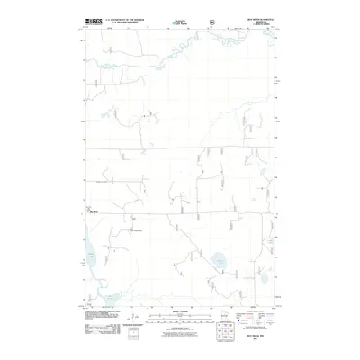
2011 Map of Boy River
USGS Topo · Published 2011About this map
The Boy River settlement serves as the central point of interest in this northern Minnesota survey, situated at a junction where the Boy River Post Office and nearby infrastructure support the local community. The landscape is defined by an intricate network of waterways, with the Leech Lake River winding across the northern section and the Boy River flowing south toward Boy Lake. These drainage patterns, including Little Bear Creek and Lucille Lake, highlight the glacial topography typical of Cass County. Local landmarks such as the Boy River Lookout Tower and Arlington Cemetery provide important points of reference for genealogists and regional historians. A grid of forest service roads and local routes, such as 3725 and 2250, indicates the area's ongoing connection to timber and land management within the forest system.
Find a feature on this map
40 named features on this map. Tap any name to fly to it.
Don’t see what you’re looking for? This feature index may not catch every label — zoom into the map to look around manually.
Map Details
Editions of this 2011 Boy River Map
This is the sole edition of this map. No revisions or reprints were ever made.
Other maps of this area

1954 · Bemidji
USGS Topo · 1:250,000

1954 · Hibbing
USGS Topo · 1:250,000

1957 · Bemidji
USGS Topo · 1:250,000

1957 · Hibbing
USGS Topo · 1:250,000

1958 · Bemidji
USGS Topo · 1:250,000

1958 · Hibbing
USGS Topo · 1:250,000

1964 · Hibbing
USGS Topo · 1:250,000

1970 · Ball Club
USGS Topo · 1:24,000
1971 · Remer
USGS Topo · 1:24,000

1971 · Nushka Lake
USGS Topo · 1:24,000