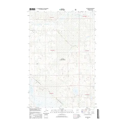
2016 Map of Boy River
USGS Topo · Published 2016About this map
The Chippewa National Forest encompasses a landscape defined by significant water systems and seasonal recreation in north-central Minnesota. The Leech Lake River meanders through the northern sections, while the namesake Boy River flows in the south, connecting to Boy Lake. This environment is shaped by extensive wetlands and glacial lakes, including Lucille Lake, Skelly Lake, and Taylor Lake. Human presence is marked by the Arlington Cem and the local infrastructure of 116th St NE. A notable feature for modern recreation and historical transport routes is the Soo Line Gia Snowmobile Trail, which cuts a diagonal path through the southwestern terrain, utilizing the former corridor of the Soo Line Railroad. This survey illustrates the continued importance of federal forest lands and the interconnected waterways that have historically supported the region's logging and seasonal tourism economies.
Find a feature on this map
17 named features on this map. Tap any name to fly to it.
Don’t see what you’re looking for? This feature index may not catch every label — zoom into the map to look around manually.
Map Details
Editions of this 2016 Boy River Map
This is the sole edition of this map. No revisions or reprints were ever made.
Other maps of this area

1954 · Bemidji
USGS Topo · 1:250,000

1954 · Hibbing
USGS Topo · 1:250,000

1957 · Bemidji
USGS Topo · 1:250,000

1957 · Hibbing
USGS Topo · 1:250,000

1958 · Bemidji
USGS Topo · 1:250,000

1958 · Hibbing
USGS Topo · 1:250,000

1964 · Hibbing
USGS Topo · 1:250,000

1970 · Ball Club
USGS Topo · 1:24,000
1971 · Remer
USGS Topo · 1:24,000

1971 · Nushka Lake
USGS Topo · 1:24,000