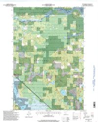
1996 Map of Boy River
USGS Topo · Published 1998About this map
The Boy River settlement sits at a crossroads of water and woodland within the northern Minnesota wilderness, where the Chippewa National Forest and Bowstring State Forest meet. This landscape is defined by its complex hydrology, dominated by the sprawling reaches of Leech Lake and Mud Goose Lake in the north, and Boy Lake to the south. The intricate network of wetlands is managed through designated areas like the Lucille Lake Impoundment, reflecting a mid-to-late 20th-century focus on wildlife habitat and water level control within the Leech Lake Indian Res. Local history is anchored by the Arlington Cemetery and the industrial presence of a Gravel Pit near the town site. The map details a remote interior where primary transport follows the Walker Deer River route and the Leech Lake River provides a natural corridor through the dense forest management areas.
Find a feature on this map
21 named features on this map. Tap any name to fly to it.
Don’t see what you’re looking for? This feature index may not catch every label — zoom into the map to look around manually.
Map Details
Editions of this 1996 Boy River Map
This is the sole edition of this map. No revisions or reprints were ever made.
Other maps of this area

1954 · Bemidji
USGS Topo · 1:250,000

1954 · Hibbing
USGS Topo · 1:250,000

1957 · Bemidji
USGS Topo · 1:250,000

1957 · Hibbing
USGS Topo · 1:250,000

1958 · Bemidji
USGS Topo · 1:250,000

1958 · Hibbing
USGS Topo · 1:250,000

1964 · Hibbing
USGS Topo · 1:250,000

1970 · Ball Club
USGS Topo · 1:24,000
1971 · Remer
USGS Topo · 1:24,000

1971 · Nushka Lake
USGS Topo · 1:24,000