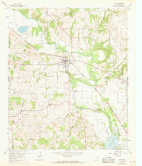
1960 Map of Boyd
USGS Topo · Published 1969About this map
The Chicago Rock Island and Pacific railroad bisects this Wise County landscape, serving the central town of Boyd and the neighboring settlement of Aurora during the mid-20th century. The West Fork Trinity River snakes through the center of the sheet, feeding into the northern reaches of Eagle Mountain Lake at the southeastern corner. This survey documents a rural environment transitioning through the 1960s, evidenced by the numerous cemeteries including Deep Creek Cem, Arkansas Cem, and Keeter Cem, which offer significant value for genealogical research in the area.
Find a feature on this map
36 named features on this map. Tap any name to fly to it.
Don’t see what you’re looking for? This feature index may not catch every label — zoom into the map to look around manually.
Map Details
Editions of this 1960 Boyd Map
3 editions found

Other maps of this area

1891 · Weatherford
USGS Topo · 1:125,000

1893 · Weatherford
USGS Topo · 1:125,000

1894 · Fort Worth
USGS Topo · 1:125,000

1924 · Sunset 4-d
USGS Topo · 1:48,000

1930 · Boyd
USGS Topo · 1:62,500

1932 · Springtown
USGS Topo · 1:62,500

1954 · Dallas
USGS Topo · 1:250,000

1954 · Sherman
USGS Topo · 1:250,000

1955 · Avondale
USGS Topo · 1:24,000

1955 · Azle
USGS Topo · 1:24,000