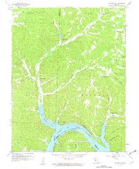
1959 Map of Boylers Mill
USGS Topo · Published 1960About this map
Boylers Mill sits in the northern reaches of this Ozark landscape, where the waters of Big Buffalo Creek and Haw Creek begin their descent toward the reservoir system. By the late 1950s, the rising waters of the Lake of the Ozarks had already reshaped the southern portion of the quadrangle, creating complex shorelines at Big Buffalo Cove and along the Osage River. This transformation of the river valley is visible in the placement of small communities like Zora and Riverview, which occupy the high ground above the flooded draws.
Find a feature on this map
39 named features on this map. Tap any name to fly to it.
Don’t see what you’re looking for? This feature index may not catch every label — zoom into the map to look around manually.
Map Details
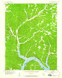
Editions of this 1959 Boylers Mill Map
2 editions found
Other maps of this area

1887 · Warsaw
USGS Topo · 1:125,000

1888 · Versailles
USGS Topo · 1:125,000

1893 · Versailles
USGS Topo · 1:125,000

1894 · Warsaw
USGS Topo · 1:125,000

1904 · Gravois Mills
USGS Topo · 1:62,500

1934 · Irontown Ferry
USGS Topo · 1:24,000

1935 · Proctor Creek
USGS Topo · 1:24,000

1935 · Edwards
USGS Topo · 1:24,000

1935 · Boylers Mill
USGS Topo · 1:24,000

1935 · Knobby Creek
USGS Topo · 1:24,000