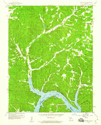
1959 Map of Boylers Mill
USGS Topo · Published 1960About this map
The northern reaches of the Lake of the Ozarks dominate the southern portion of this landscape, where the Big Buffalo Cove meets the rising terrain of Athens Bluffs. Near the northern border, the community of Boylers Mill sits along the winding path of Big Buffalo Creek, accompanied by a local Fish Hatchery. The settlement patterns of the mid-20th century are evident through the distribution of small community centers such as Zora and Riverview, as well as several rural gathering places. Genealogists and local historians can find specifically marked locations for the Big Buffalo Sch, Trinity Chapel, and Mt Calvary Ch. The map also illustrates the topographic transition from the river valleys to higher points like Mt Hulda Lookout Tower, providing a clear view of the area's geography before further modern development altered these Ozark watersheds.
Find a feature on this map
36 named features on this map. Tap any name to fly to it.
Don’t see what you’re looking for? This feature index may not catch every label — zoom into the map to look around manually.
Map Details
Editions of this 1959 Boylers Mill Map
2 editions found
Other maps of this area

1887 · Warsaw
USGS Topo · 1:125,000

1888 · Versailles
USGS Topo · 1:125,000

1893 · Versailles
USGS Topo · 1:125,000

1894 · Warsaw
USGS Topo · 1:125,000

1904 · Gravois Mills
USGS Topo · 1:62,500

1934 · Irontown Ferry
USGS Topo · 1:24,000

1935 · Proctor Creek
USGS Topo · 1:24,000

1935 · Edwards
USGS Topo · 1:24,000

1935 · Boylers Mill
USGS Topo · 1:24,000

1935 · Knobby Creek
USGS Topo · 1:24,000