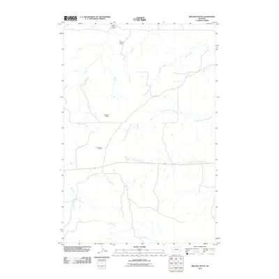
2011 Map of Bracket Butte
USGS Topo · Published 2011About this map
Cottonwood Cemetery and the prominent landmark of Bracket Butte anchor this section of Fallon County, Montana, as it appeared in the early 21st century. The landscape is defined by an intricate network of drainages, including the branching paths of the North Fork Cottonwood Creek and South Fork Cottonwood Creek, which converge amidst several smaller waterways like Ash Creek and Station Creek. Water management in this high-plains environment is evident through infrastructure such as the Gray Number 1 Dam and Gray Number 3 Dam in the north. Settlement is sparse, with transportation primarily facilitated by 11 Mile Rd and a few improved routes crossing the creek beds, reflecting a rural ranching or agricultural pattern typical of the region. The map provides a precise look at the hydrology of the area, tracing the winding courses of Dry Creek, Archdale Creek, and Spring Creek.
Find a feature on this map
12 named features on this map. Tap any name to fly to it.
Don’t see what you’re looking for? This feature index may not catch every label — zoom into the map to look around manually.
Map Details
Editions of this 2011 Bracket Butte Map
This is the sole edition of this map. No revisions or reprints were ever made.
Other maps of this area

1953 · Miles City
USGS Topo · 1:250,000

1957 · Miles City
USGS Topo · 1:250,000

1958 · Miles City
USGS Topo · 1:250,000

1969 · Little Whitney Creek
USGS Topo · 1:24,000

1969 · Knowlton
USGS Topo · 1:24,000

1969 · Montague Butte
USGS Topo · 1:24,000

1980 · Terry
USGS Topo · 1:100,000
1980 · Miles City
USGS Topo · 1:100,000

1981 · Baker
USGS Topo · 1:100,000
1981 · Bracket Butte
USGS Topo · 1:24,000