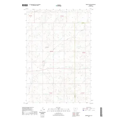
2020 Map of Bracket Butte
USGS Topo · Published 2020About this map
Bracket Butte rises as the central topographical landmark in this corner of Eastern Montana, situated along the county line between Fallon and Custer counties. This area of the plains is defined by a dense network of seasonal drainages, including N Fork Cottonwood Cr and S Fork Cottonwood Cr, which carve through the high ground surrounding the butte. The presence of the Cottonwood Cem near Co Rd 337 provides a specific point of interest for genealogists researching families from the local ranching and farming communities. The map details the rural infrastructure of the early 21st century, showing remote routes like Whitney Cr Rd and 11 Mile Rd that connect isolated holdings across the townships of t8n r54e and t9n r54e.
Find a feature on this map
20 named features on this map. Tap any name to fly to it.
Don’t see what you’re looking for? This feature index may not catch every label — zoom into the map to look around manually.
Map Details
Editions of this 2020 Bracket Butte Map
This is the sole edition of this map. No revisions or reprints were ever made.
Other maps of this area

1953 · Miles City
USGS Topo · 1:250,000

1957 · Miles City
USGS Topo · 1:250,000

1958 · Miles City
USGS Topo · 1:250,000

1969 · Little Whitney Creek
USGS Topo · 1:24,000

1969 · Knowlton
USGS Topo · 1:24,000

1969 · Montague Butte
USGS Topo · 1:24,000

1980 · Terry
USGS Topo · 1:100,000
1980 · Miles City
USGS Topo · 1:100,000

1981 · Baker
USGS Topo · 1:100,000
1981 · Bracket Butte
USGS Topo · 1:24,000