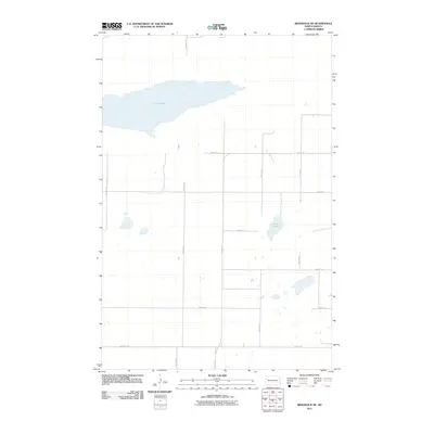
2011 Map of Braddock NE
USGS Topo · Published 2011About this map
Long Lake dominates the northern landscape of this prairie terrain in Campbell Township, reflecting the characteristic glacial geography of the region. The map reveals a highly structured section-line road network typical of the Great Plains, where routes like 154th Ave SE and 444th St SE form a rigid grid across the land. This spatial organization illustrates the enduring legacy of the Public Land Survey System in Emmons County, defining property boundaries and transit corridors. Beyond the larger water body, smaller depressions and ephemeral basins such as Mud Lake are scattered across the southern sections. This 2011 survey captures the area at a time when the rural landscape remained largely dedicated to agriculture and open space, with modern infrastructure subtly layered over the historical township structure.
Find a feature on this map
17 named features on this map. Tap any name to fly to it.
Don’t see what you’re looking for? This feature index may not catch every label — zoom into the map to look around manually.
Map Details
Editions of this 2011 Braddock NE Map
This is the sole edition of this map. No revisions or reprints were ever made.
Other maps of this area

1951 · Driscoll
USGS Topo · 1:62,500

1952 · Steele
USGS Topo · 1:24,000

1953 · Jamestown
USGS Topo · 1:250,000

1954 · Bismarck
USGS Topo · 1:250,000

1956 · Jamestown
USGS Topo · 1:250,000

1958 · Bismarck
USGS Topo · 1:250,000

1975 · Lake Geneva
USGS Topo · 1:24,000
1975 · Driscoll
USGS Topo · 1:24,000

1975 · Dana
USGS Topo · 1:24,000
1975 · Braddock NW
USGS Topo · 1:24,000