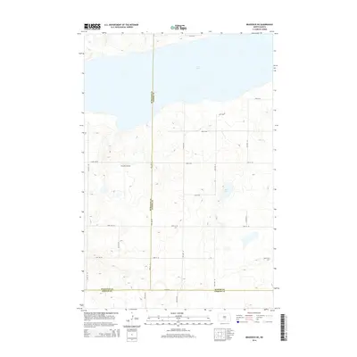
2014 Map of Braddock NE
USGS Topo · Published 2014About this map
Long Lake dominates the northern horizon of this North Dakota landscape, its expansive waters stretching across the border of Burleigh and Kidder counties. The terrain is defined by a dense network of glacial prairie potholes and small depressions, creating a complex hydrology south of the main lake. This 2014 survey reveals a highly organized rural infrastructure, where the section lines of the Public Land Survey System are manifest in a rigid grid of roads like 50th St SE and 18th Ave SE. A notable landmark for regional transit and agriculture is the Preszler Airstrip, situated among the rolling contours west of Mud Lake. The convergence of three county lines—Burleigh, Kidder, and Emmons—at the southern edge of the sheet underscores the map's significance for property research and jurisdictional history in this agricultural heartland.
Find a feature on this map
27 named features on this map. Tap any name to fly to it.
Don’t see what you’re looking for? This feature index may not catch every label — zoom into the map to look around manually.
Map Details
Editions of this 2014 Braddock NE Map
This is the sole edition of this map. No revisions or reprints were ever made.
Other maps of this area

1951 · Driscoll
USGS Topo · 1:62,500

1952 · Steele
USGS Topo · 1:24,000

1953 · Jamestown
USGS Topo · 1:250,000

1954 · Bismarck
USGS Topo · 1:250,000

1956 · Jamestown
USGS Topo · 1:250,000

1958 · Bismarck
USGS Topo · 1:250,000

1975 · Lake Geneva
USGS Topo · 1:24,000
1975 · Driscoll
USGS Topo · 1:24,000

1975 · Dana
USGS Topo · 1:24,000
1975 · Braddock NW
USGS Topo · 1:24,000