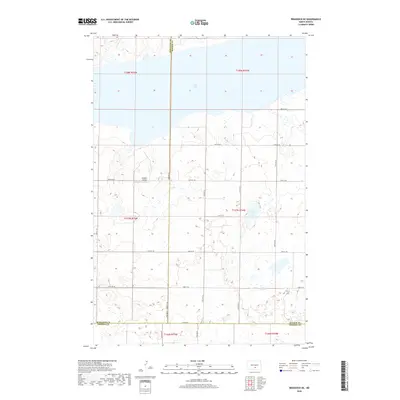
2018 Map of Braddock NE
USGS Topo · Published 2018About this map
The expansive waters of Long Lake dominate the northern landscape of this prairie region, where the borders of Burleigh, Kidder, and Emmons counties converge. This 2018 survey reveals a terrain defined by glacial depressions and intermittent wetlands, including the appropriately named Mud Lake to the southeast. Human presence is marked by the rectilinear grid of section roads, such as 54th St SE and 102nd Ave SE, which navigate the rises and hollows of the North Dakota plains. A notable local landmark is the Preszler Airstrip, a small private runway that reflects the reliance on light aircraft for transport in this sparsely settled agricultural territory. The map illustrates the persistent intersection of township lines, such as t137n r75w, within a landscape that remains largely dedicated to large-scale farming and waterfowl habitat.
Find a feature on this map
22 named features on this map. Tap any name to fly to it.
Don’t see what you’re looking for? This feature index may not catch every label — zoom into the map to look around manually.
Map Details
Editions of this 2018 Braddock NE Map
This is the sole edition of this map. No revisions or reprints were ever made.
Other maps of this area

1951 · Driscoll
USGS Topo · 1:62,500

1952 · Steele
USGS Topo · 1:24,000

1953 · Jamestown
USGS Topo · 1:250,000

1954 · Bismarck
USGS Topo · 1:250,000

1956 · Jamestown
USGS Topo · 1:250,000

1958 · Bismarck
USGS Topo · 1:250,000

1975 · Lake Geneva
USGS Topo · 1:24,000
1975 · Driscoll
USGS Topo · 1:24,000

1975 · Dana
USGS Topo · 1:24,000
1975 · Braddock NW
USGS Topo · 1:24,000