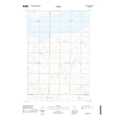
2020 Map of Braddock NE
USGS Topo · Published 2020About this map
Long Lake dominates the northern horizon of this North Dakota landscape, situated at the convergence of Burleigh, Kidder, and Emmons counties. The terrain is defined by a dense network of sectional roads, including 102nd Ave SE and 141st Ave SE, which organize the agricultural prairie into a precise grid. This 2020 survey illustrates the continued importance of remote infrastructure, such as the Preszler Airstrip, which serves the isolated farmsteads across the township lines. Smaller depressions like Mud Lake dot the eastern sections, reflecting the glaciated topography of the region. The map meticulously records the administrative boundaries where t137n r75w meets its neighboring townships, providing a clear view of the rural land divisions and transport corridors that sustain this prairie community.
Find a feature on this map
28 named features on this map. Tap any name to fly to it.
Don’t see what you’re looking for? This feature index may not catch every label — zoom into the map to look around manually.
Map Details
Editions of this 2020 Braddock NE Map
This is the sole edition of this map. No revisions or reprints were ever made.
Other maps of this area

1951 · Driscoll
USGS Topo · 1:62,500

1952 · Steele
USGS Topo · 1:24,000

1953 · Jamestown
USGS Topo · 1:250,000

1954 · Bismarck
USGS Topo · 1:250,000

1956 · Jamestown
USGS Topo · 1:250,000

1958 · Bismarck
USGS Topo · 1:250,000

1975 · Lake Geneva
USGS Topo · 1:24,000
1975 · Driscoll
USGS Topo · 1:24,000

1975 · Dana
USGS Topo · 1:24,000
1975 · Braddock NW
USGS Topo · 1:24,000