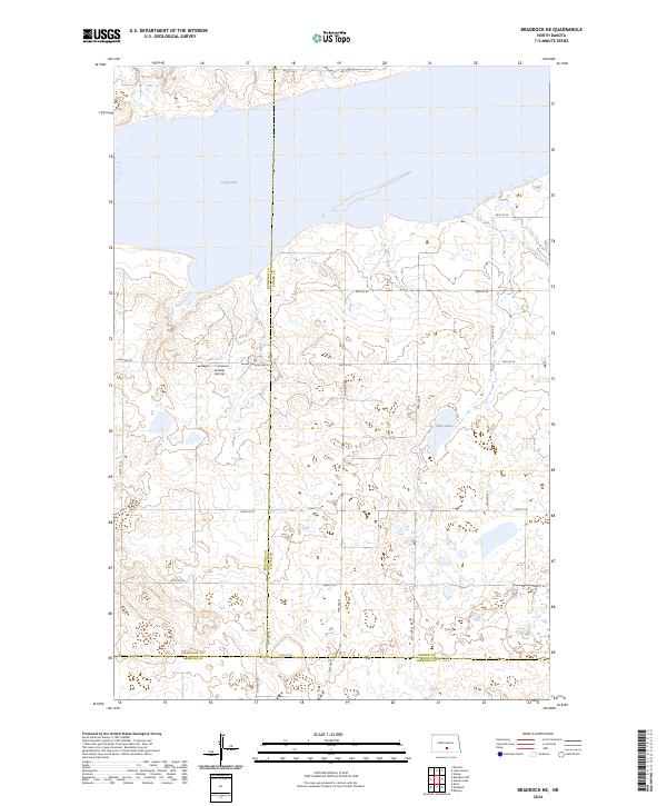
2024 Map of Braddock NE
USGS Topo · Published 2024About this map
Long Lake National Wildlife Refuge dominates the northern landscape of this region where Burleigh, Kidder, and Emmons counties meet. This prairie pothole environment is defined by extensive wetlands and shallow water bodies like Long Lake and Mud Lake, which provide critical habitat in a predominantly agricultural setting. The map reveals a strict section-line road grid, including routes such as 102nd Ave SE and 46th St SE, which partition the undulating terrain into distinct parcels. A notable private landmark, the Preszler Airstrip, sits centrally among these fields, illustrating the reliance on local aviation in this sparsely populated interior. The absence of traditional townsites emphasizes the rural, conservation-focused character of this specific corner of the North Dakota plains during the early twenty-first century.
Find a feature on this map
25 named features on this map. Tap any name to fly to it.
Don’t see what you’re looking for? This feature index may not catch every label — zoom into the map to look around manually.
Map Details
Editions of this 2024 Braddock NE Map
This is the sole edition of this map. No revisions or reprints were ever made.
Other maps of this area

1951 · Driscoll
USGS Topo · 1:62,500

1952 · Steele
USGS Topo · 1:24,000

1953 · Jamestown
USGS Topo · 1:250,000

1954 · Bismarck
USGS Topo · 1:250,000

1956 · Jamestown
USGS Topo · 1:250,000

1958 · Bismarck
USGS Topo · 1:250,000

1975 · Lake Geneva
USGS Topo · 1:24,000
1975 · Driscoll
USGS Topo · 1:24,000

1975 · Dana
USGS Topo · 1:24,000
1975 · Braddock NW
USGS Topo · 1:24,000