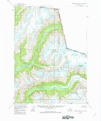
1955 Map of Bradfield canal A-2
USGS Topo · Published 1962About this map
Leduc River and the Chickamin River carve through this high-altitude landscape along the international boundary between Canada and the United States. The mid-century survey illustrates an environment defined by expansive ice fields and named peaks, where the British Columbia border is marked by a series of geodetic monuments atop summits like Mt Willibert and Mt. Upshur. The drainage patterns are dominated by massive glacial systems, including the Clara Smith Glacier and Through Glacier, which feed into the primary river valleys. This map captures the region before the formal designation of the Misty Fiords National Monument, showing the land as part of the broader Tongass National Forest. The absence of roads or permanent settlements highlights the isolation of this borderland, where travel was dictated by watercourses and the shifting margins of the Chickamin Glacier.
Find a feature on this map
18 named features on this map. Tap any name to fly to it.
Don’t see what you’re looking for? This feature index may not catch every label — zoom into the map to look around manually.
Map Details
Editions of this 1955 Bradfield canal A-2 Map
3 editions found
Other maps of this area

1951 · Bradfield Canal
USGS Topo · 1:250,000

1952 · Ketchikan
USGS Topo · 1:250,000

1954 · Bradfield Canal
USGS Topo · 1:250,000

1955 · Bradfield canal B-2
USGS Topo · 1:63,360

1955 · Ketchikan D-2
USGS Topo · 1:63,360

1955 · Bradfield canal B-3
USGS Topo · 1:63,360

1955 · Bradfield canal A-2
USGS Topo · 1:63,360

1955 · Ketchikan D-3
USGS Topo · 1:63,360

1955 · Bradfield Canal A-1
USGS Topo · 1:63,360

1955 · Ketchikan D-1
USGS Topo · 1:63,360