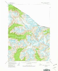
1955 Map of Bradfield canal B-4
USGS Topo · Published 1982About this map
The international boundary between British Columbia and the United States cuts diagonally across this 1955 survey of the Alaskan panhandle. The landscape is defined by the steep drainage basins of the Bradfield River and its major tributaries, including the North Fork and East Fork. This is a wilderness of dramatic elevation, dominated by high peaks such as Mt Pounder and Mt Lewis Cass along the border, and Mt Cloud further south. The map documents large portions of the Tongass National Forest and the Misty Fjords National Monument, illustrating the transition from glacial headwaters to the river systems that feed into the canal. In the northwest corner, the South Fork Craig River flows through deep valleys, while the Blue River carves through the eastern reaches of the monument.
Find a feature on this map
12 named features on this map. Tap any name to fly to it.
Don’t see what you’re looking for? This feature index may not catch every label — zoom into the map to look around manually.
Map Details
Editions of this 1955 Bradfield canal B-4 Map
3 editions found
Other maps of this area

1951 · Bradfield Canal
USGS Topo · 1:250,000

1954 · Bradfield Canal
USGS Topo · 1:250,000

1955 · Bradfield canal B-3
USGS Topo · 1:63,360

1955 · Bradfield canal A-4
USGS Topo · 1:63,360

1955 · Bradfield canal B-5
USGS Topo · 1:63,360

1955 · Bradfield canal B-4
USGS Topo · 1:63,360

1955 · Bradfield Canal A-5
USGS Topo · 1:63,360
1955 · Bradfield Canal C-5
USGS Topo · 1:63,360

1955 · Bradfield canal A-3
USGS Topo · 1:63,360

1955 · Bradfield Canal
USGS Topo · 1:250,000