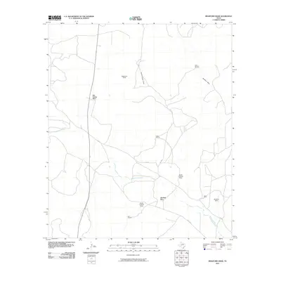
2010 Map of Bradford Draw
USGS Topo · Published 2010About this map
Old Burk Place and Old Freitag Place anchor this rural Irion County landscape, where the seasonal hydrology of West Texas dictates the placement of roads and homesteads. The meandering Middle Concho River cuts across the lower half of the quadrangle, joined by a network of drainage features including North Liveoak Draw and South Liveoak Draw. This environment is defined by its reliance on groundwater, evidenced by named landmarks like Upper Bradford Windmill, South Windmill, and Bluff Windmill which serve the local ranching economy. The road network is sparse, with Co RD 411 and Wales RD providing the primary routes through the open country. The presence of named ranches and historic sites such as the Sheen Ranch reflects the persistent ranching traditions of the Edwards Plateau. The terrain is marked by significant ephemeral washes like Telephone Draw and Bradford Draw, illustrating the complex drainage patterns of this semi-arid region.
Find a feature on this map
14 named features on this map. Tap any name to fly to it.
Don’t see what you’re looking for? This feature index may not catch every label — zoom into the map to look around manually.
Map Details
Editions of this 2010 Bradford Draw Map
This is the sole edition of this map. No revisions or reprints were ever made.
Other maps of this area

1895 · Sherwood
USGS Topo · 1:125,000

1921 · Ketchum Mountain
USGS Topo · 1:62,500

1923 · Ketchum Mountain
USGS Topo · 1:62,500

1954 · San Angelo
USGS Topo · 1:250,000

1958 · San Angelo
USGS Topo · 1:250,000

1965 · San Angelo
USGS Topo · 1:250,000

1972 · Wallace Draw
USGS Topo · 1:24,000
1972 · Mertzon SW
USGS Topo · 1:24,000

1972 · Dog Creek SW
USGS Topo · 1:24,000

1973 · Hay Hollow
USGS Topo · 1:24,000