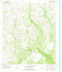
1973 Map of Bradford Draw
USGS Topo · Published 1975About this map
The Middle Concho River winds through this Irion County landscape, where the convergence of several major drainages like Bradford Draw and North Liveoak Draw dictated the patterns of ranching and early settlement. This 1973 survey highlights the essential role of water in the West, documented by numerous landmarks such as the Upper Bradford Windmill, South Windmill, and Bluff Windmill. These features, alongside named locations like the Old Freitag Place and Old Burk Place, provide a clear record of the specific families and operations that managed this territory. While cattle and water dominate the surface, the presence of a Gas Well, a Pipeline, and multiple Gravel Pits reflects the diversification of local industry into mineral and resource extraction during the early 1970s.
Find a feature on this map
17 named features on this map. Tap any name to fly to it.
Don’t see what you’re looking for? This feature index may not catch every label — zoom into the map to look around manually.
Map Details
Editions of this 1973 Bradford Draw Map
This is the sole edition of this map. No revisions or reprints were ever made.
Other maps of this area

1895 · Sherwood
USGS Topo · 1:125,000

1921 · Ketchum Mountain
USGS Topo · 1:62,500

1923 · Ketchum Mountain
USGS Topo · 1:62,500

1954 · San Angelo
USGS Topo · 1:250,000

1958 · San Angelo
USGS Topo · 1:250,000

1965 · San Angelo
USGS Topo · 1:250,000

1972 · Wallace Draw
USGS Topo · 1:24,000
1972 · Mertzon SW
USGS Topo · 1:24,000

1972 · Dog Creek SW
USGS Topo · 1:24,000

1973 · Hay Hollow
USGS Topo · 1:24,000