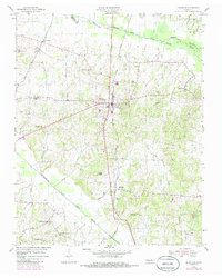
1954 Map of Bradford
USGS Topo · Published 1985About this map
The town of Bradford serves as the central hub of this West Tennessee landscape, situated along the Illinois Central Gulf railroad line. The map documents a deeply rooted agricultural and social network defined by numerous community churches and their associated cemeteries, such as Griffins Chapel, Shiloh Ch, and Antioch Ch. These small settlements, including Skullbone and Idlewild, are connected by a web of rural roads that traverse the drainage basins of the South Fork Obion River and the Rutherford Fork Obion River.
Find a feature on this map
41 named features on this map. Tap any name to fly to it.
Don’t see what you’re looking for? This feature index may not catch every label — zoom into the map to look around manually.
Map Details
Editions of this 1954 Bradford Map
3 editions found
Other maps of this area

1951 · Trenton
USGS Topo · 1:24,000

1952 · Milan
USGS Topo · 1:24,000

1953 · Dyer
USGS Topo · 1:24,000

1954 · Rutherford
USGS Topo · 1:24,000

1954 · Greenfield
USGS Topo · 1:24,000

1954 · Bradford
USGS Topo · 1:24,000

1956 · Dyersburg
USGS Topo · 1:250,000

1956 · Blytheville
USGS Topo · 1:250,000

1959 · Blytheville
USGS Topo · 1:250,000

1966 · Atwood
USGS Topo · 1:24,000