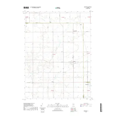
2018 Map of Bradford
USGS Topo · Published 2018About this map
The E Fork Spoon River and its various tributaries, including Silver Cr and Fox Cr, shape the landscape of this rural Illinois region. Centered on the town of Bradford, the area shows a clear pattern of agricultural land division defined by long-established road grids like 600 North Ave and 1700 E. Several small settlements punctuate the terrain, including Lombardville, Morse, and Broadmoor, reflecting the historical importance of local rail and road junctions.
Find a feature on this map
40 named features on this map. Tap any name to fly to it.
Don’t see what you’re looking for? This feature index may not catch every label — zoom into the map to look around manually.
Map Details
Editions of this 2018 Bradford Map
This is the sole edition of this map. No revisions or reprints were ever made.
Other maps of this area

1921 · Buda
USGS Topo · 1:62,500

1923 · Buda
USGS Topo · 1:62,500

1929 · Annawan
USGS Topo · 1:62,500

1932 · Annawan
USGS Topo · 1:62,500

1933 · Camp Grove
USGS Topo · 1:48,000

1944 · Kewanee
USGS Topo · 1:62,500

1945 · Bradford
USGS Topo · 1:62,500

1958 · Aurora
USGS Topo · 1:250,000

1961 · Aurora
USGS Topo · 1:250,000
1983 · Castleton
USGS Topo · 1:24,000