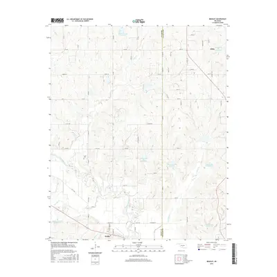
2016 Map of Bradley
USGS Topo · Published 2016About this map
The Washita River meanders across the southern portion of this landscape, defining the topography near the community of Bradley. This region along the boundary of Grady and McClain counties is characterized by an extensive network of managed water resources, including numerous flood control structures such as Winter Creek Site 15 Reservoir and the Bear Hybarger Site 3a Reservoir. These engineered basins sit among the drainage systems of Laflin Cr and Colbert Cr, which feed toward the main river valley.
Find a feature on this map
65 named features on this map. Tap any name to fly to it.
Don’t see what you’re looking for? This feature index may not catch every label — zoom into the map to look around manually.
Map Details
Editions of this 2016 Bradley Map
This is the sole edition of this map. No revisions or reprints were ever made.
Other maps of this area

1902 · Rush Springs
USGS Topo · 1:125,000

1904 · Chickasha
USGS Topo · 1:125,000

1949 · Rush Springs
USGS Topo · 1:62,500

1950 · Rush Springs
USGS Topo · 1:62,500

1954 · Oklahoma City
USGS Topo · 1:250,000

1957 · Ardmore
USGS Topo · 1:250,000

1957 · Oklahoma City
USGS Topo · 1:250,000

1963 · Ardmore
USGS Topo · 1:250,000

1963 · Oklahoma City
USGS Topo · 1:250,000
1965 · Cole
USGS Topo · 1:24,000