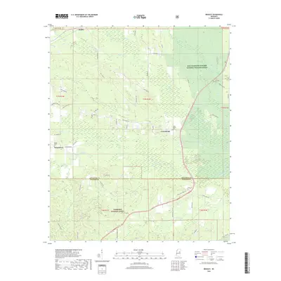
2018 Map of Bradley
USGS Topo · Published 2018About this map
Bradley and Morgantown anchor a landscape defined by the intersection of forest and wildlife management areas in the late 2010s. The northern portion of the region is dominated by the Sam D Hamilton Noxubee National Wildlife Refuge, while the southern reaches fall within the Tombigbee National Forest. The Noxubee River and Parker Slough wind through the central lowlands, creating a wetland environment that historically influenced the development of small settlements like Craig Springs. Genealogists will find a significant distribution of family and community burial sites, including Morgan Chapel Cem, McClelland Cem, and Pugh Cem. The map reveals a intricate network of local roads such as Silver Ridge Rd and Hamill Hill Rd, tracing the transition from the rolling hills of the national forest to the protected floodplains of the refuge.
Find a feature on this map
64 named features on this map. Tap any name to fly to it.
Don’t see what you’re looking for? This feature index may not catch every label — zoom into the map to look around manually.
Map Details
Editions of this 2018 Bradley Map
This is the sole edition of this map. No revisions or reprints were ever made.
Other maps of this area

1953 · West Point
USGS Topo · 1:250,000

1958 · West Point
USGS Topo · 1:250,000

1963 · West Point
USGS Topo · 1:250,000

1965 · Starkville
USGS Topo · 1:24,000

1965 · Bluff Lake
USGS Topo · 1:24,000

1965 · Longview
USGS Topo · 1:24,000

1965 · Bradley
USGS Topo · 1:24,000

1972 · Louisville North
USGS Topo · 1:24,000

1972 · Double Springs
USGS Topo · 1:24,000

1972 · Sturgis
USGS Topo · 1:24,000