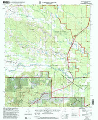
2000 Map of Bradley
USGS Topo · Published 2002About this map
Noxubee River winding through the dense timberlands of north-central Mississippi characterizes this landscape at the turn of the millennium. The survey documents a complex intersection of academic, federal, and local interests, prominently featuring the Mississippi State University School of Forest Resources alongside the Noxubee National Wildlife Refuge and the Tombigbee National Forest. Small, traditional communities like Bradley and Morgantown anchor the area, while a network of country churches including Friendship Ch and Silver Ridge Ch reflect the rural social fabric of Oktibbeha and Winston counties. The terrain is defined by a dense drainage system of creeks, such as Cypress Creek, Chinchahoma Creek, and Sand Creek, which helped shape the settlement patterns and forestry operations that remain central to the region's identity and economy.
Find a feature on this map
36 named features on this map. Tap any name to fly to it.
Don’t see what you’re looking for? This feature index may not catch every label — zoom into the map to look around manually.
Map Details
Editions of this 2000 Bradley Map
This is the sole edition of this map. No revisions or reprints were ever made.
Other maps of this area

1953 · West Point
USGS Topo · 1:250,000

1958 · West Point
USGS Topo · 1:250,000

1963 · West Point
USGS Topo · 1:250,000

1965 · Starkville
USGS Topo · 1:24,000

1965 · Bluff Lake
USGS Topo · 1:24,000

1965 · Longview
USGS Topo · 1:24,000

1965 · Bradley
USGS Topo · 1:24,000

1972 · Louisville North
USGS Topo · 1:24,000

1972 · Double Springs
USGS Topo · 1:24,000

1972 · Sturgis
USGS Topo · 1:24,000