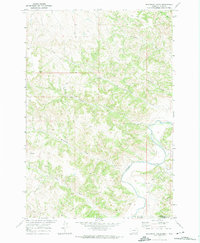
1970 Map of Bradshaw Creek
USGS Topo · Published 1974About this map
The Powder River carves a distinct path through this section of the Montana-Wyoming borderlands, a landscape defined by sharp elevation shifts and an intricate drainage network. In the south, the Spear Hills and the prominent Black Eagle Butte overlook a series of winding seasonal waterways including Bitter Creek and Dry Cr. This 1970 field-checked survey reveals a territory primarily shaped by livestock management and mineral exploration, evidenced by scattered corrals and several drill holes throughout the terrain.
Find a feature on this map
17 named features on this map. Tap any name to fly to it.
Don’t see what you’re looking for? This feature index may not catch every label — zoom into the map to look around manually.
Map Details
Editions of this 1970 Bradshaw Creek Map
This is the sole edition of this map. No revisions or reprints were ever made.
Other maps of this area

1954 · Hardin
USGS Topo · 1:250,000

1954 · Ekalaka
USGS Topo · 1:250,000

1954 · Gillette
USGS Topo · 1:250,000

1955 · Sheridan
USGS Topo · 1:250,000

1955 · Gillette
USGS Topo · 1:250,000

1956 · Ekalaka
USGS Topo · 1:250,000

1957 · Hardin
USGS Topo · 1:250,000

1958 · Gillette
USGS Topo · 1:250,000

1958 · Ekalaka
USGS Topo · 1:250,000

1958 · Hardin
USGS Topo · 1:250,000