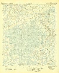
1945 Map of Bradwell Bay
USGS Topo · Published 1945About this map
Apalachicola National Forest dominates this mid-1940s survey, representing a vast expanse of the Florida Panhandle's wetland interior. The landscape is defined by the expansive Bradwell Bay, a massive swampy depression characterized by dense forest and intricate drainage patterns. The Sopchoppy River meanders across the upper portion of the quadrangle, serving as a primary hydrological artery through the timbered lowlands. Mapping conducted by the Geological Survey during the war years of 1943-1944 reveals a wilderness largely devoid of permanent settlement, where the only structural markers are occasional bench marks and the section lines of the public land survey system. The presence of Monkey Creek in the southeastern quadrant further illustrates the complex network of slow-moving waterways that dictated the accessibility and use of this Floridian backcountry before modern drainage and development altered the region.
Find a feature on this map
5 named features on this map. Tap any name to fly to it.
Don’t see what you’re looking for? This feature index may not catch every label — zoom into the map to look around manually.
Map Details
Editions of this 1945 Bradwell Bay Map
4 editions found
Other maps of this area

1940 · Tallahassee
USGS Topo · 1:62,500

1940 · Arran
USGS Topo · 1:62,500

1942 · Tallahassee
USGS Topo · 1:62,500

1943 · Arran
USGS Topo · 1:62,500

1943 · Tallahassee
USGS Topo · 1:62,500

1943 · Lake Talquin
USGS Topo · 1:62,500

1945 · Thousand Yard Bay
USGS Topo · 1:31,680

1945 · Smith Creek
USGS Topo · 1:31,680

1945 · Bradwell Bay
USGS Topo · 1:31,680

1945 · Sanborn
USGS Topo · 1:31,680