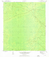
1945 Map of Bradwell Bay
USGS Topo · Published 1960About this map
Apalachicola National Forest encompasses this section of the Florida panhandle, characterized by a complex network of wetlands and river systems. The Sopchoppy River snakes through the northern and eastern portions of the quadrangle, serving as a primary drainage for the surrounding terrain. This landscape is dominated by the sprawling swamp of Bradwell Bay and the smaller Mosquito Bay, illustrating the wet, undeveloped character of this region in the mid-1940s. These vast "bays" are not open water but dense forest swamps typical of the Gulf Coastal Plain. Scattered benchmark markers and a solitary winding road suggest the limited human footprint within these protected federal lands. Further south, Monkey Creek meanders through the wetlands, joining the intricate hydrological pattern that has historically shaped the timber and wilderness identity of Wakulla County.
Find a feature on this map
6 named features on this map. Tap any name to fly to it.
Don’t see what you’re looking for? This feature index may not catch every label — zoom into the map to look around manually.
Map Details
Editions of this 1945 Bradwell Bay Map
4 editions found
Other maps of this area

1940 · Tallahassee
USGS Topo · 1:62,500

1940 · Arran
USGS Topo · 1:62,500

1942 · Tallahassee
USGS Topo · 1:62,500

1943 · Arran
USGS Topo · 1:62,500

1943 · Tallahassee
USGS Topo · 1:62,500

1943 · Lake Talquin
USGS Topo · 1:62,500

1945 · Thousand Yard Bay
USGS Topo · 1:31,680

1945 · Smith Creek
USGS Topo · 1:31,680

1945 · Bradwell Bay
USGS Topo · 1:31,680

1945 · Sanborn
USGS Topo · 1:31,680