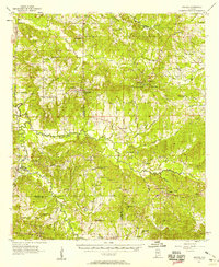
1957 Map of Braggs
USGS Topo · Published 1958About this map
Old Town and the neighboring hills of Lowndes and Dallas Counties define this rural landscape during the late 1950s. The map captures a high density of small-scale community hubs, with dozens of churches and schools scattered across the terrain, reflecting the social geography of the Black Belt. Of particular interest is the Berlin Normal Sch and the community of Pleasant Hill, which was served by the Pleasant Hill Station.
Find a feature on this map
60 named features on this map. Tap any name to fly to it.
Don’t see what you’re looking for? This feature index may not catch every label — zoom into the map to look around manually.
Map Details
Editions of this 1957 Braggs Map
2 editions found
Other maps of this area

1953 · Montgomery
USGS Topo · 1:250,000

1953 · Andalusia
USGS Topo · 1:250,000

1956 · Montgomery
USGS Topo · 1:250,000

1957 · Montgomery
USGS Topo · 1:250,000

1957 · Andalusia
USGS Topo · 1:250,000

1957 · Autaugaville
USGS Topo · 1:62,500

1957 · Carlowville
USGS Topo · 1:62,500

1957 · Benton
USGS Topo · 1:62,500

1957 · Braggs
USGS Topo · 1:62,500

1958 · Selma
USGS Topo · 1:62,500