
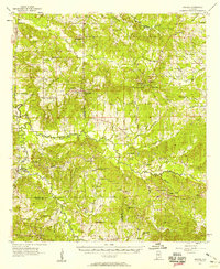
1957 Map of Braggs
USGS Topo · Published 1958About this map
The rolling landscape of southern Alabama in the late 1950s is defined by a dense network of rural schools and churches that served the communities of Lowndes, Dallas, and Wilcox Counties. Centers of learning such as the Berlin Normal Sch and Mt Ararat Sch stand alongside numerous congregational landmarks like New Bethel Ch and Old Bethel Ch. The Louisville and Nashville railroad tracks cut through the western portion of the region, connecting the settlement of Minter (Minters Sta) and Pleasant Hill Station to wider trade routes. Deeply incised drainage patterns, including Dry Cedar Creek and Mush Creek, dictate the placement of roads and homesteads. The presence of Nixon Hall and Community Hall suggests active civic life in these agricultural outposts, while settlements like Pleasant Hill and Furman serve as primary anchors for the surrounding farmsteads.
Find a feature on this map
63 named features on this map. Tap any name to fly to it.
Don’t see what you’re looking for? This feature index may not catch every label — zoom into the map to look around manually.
Map Details
Editions of this 1957 Braggs Map
2 editions found
Other maps of this area

1953 · Montgomery
USGS Topo · 1:250,000

1953 · Andalusia
USGS Topo · 1:250,000

1956 · Montgomery
USGS Topo · 1:250,000

1957 · Montgomery
USGS Topo · 1:250,000

1957 · Andalusia
USGS Topo · 1:250,000

1957 · Autaugaville
USGS Topo · 1:62,500

1957 · Carlowville
USGS Topo · 1:62,500

1957 · Benton
USGS Topo · 1:62,500

1958 · Selma
USGS Topo · 1:62,500

1971 · Fort Dale
USGS Topo · 1:24,000