
1915 Map of Brainerd
USGS Topo · Published 1960About this map
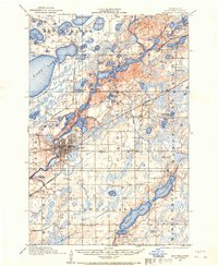
Brainerd sits as a vital rail and river hub during the early twentieth century, where the Mississippi River meets the steel rails of the Northern Pacific and Minnesota International railroads. This survey, conducted by F.B. Barrett and J.H. Wilson, reveals a landscape transitioning from wild lakes to a rural community defined by numbered school districts. The township boundaries of Lake Edwards, Oak, and Nokay contain a network of small settlements like Merrifield and Riverton that supported the local economy.
Find a feature on this map
65 named features on this map. Tap any name to fly to it.
Don’t see what you’re looking for? This feature index may not catch every label — zoom into the map to look around manually.
Map Details
Editions of this 1915 Brainerd Map
2 editions found
Other maps of this area

1912 · Deerwood
USGS Topo · 1:62,500

1913 · Cuyuna
USGS Topo · 1:62,500

1914 · Deerwood
USGS Topo · 1:62,500

1915 · Cuyuna
USGS Topo · 1:62,500

1916 · Pillager
USGS Topo · 1:62,500

1918 · Brainerd
USGS Topo · 1:62,500

1919 · Pillager
USGS Topo · 1:62,500

1948 · Belle Prairie
USGS Topo · 1:62,500

1948 · Lastrup
USGS Topo · 1:62,500

1950 · Lastrup
USGS Topo · 1:62,500