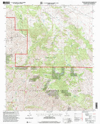
1995 Map of Branch Mountain
USGS Topo · Published 2000About this map
Los Padres National Forest spans the majority of this mid-1990s survey, a landscape defined by sharp ridges and isolated ranching outposts. The high point of Branch Mountain serves as a critical vantage point, housing a Branch Mountain Lookout that monitors the complex terrain of Barrett Ridge and Sycamore Ridge. The hydrology of the area is dominated by intermittent drainages like Rafael Creek and San Juan Creek, which carve deep paths through the backcountry. Human activity is largely limited to cattle operations and forest management, evidenced by the presence of the Carrisa Ranch, Buckhorn Ranch, and Luelling Ranch. These family-named landholdings, along with numerous named water sources like Grizzly Spring and Thompson Spring, provide essential orientation markers for researchers tracing the mid-century agricultural and forest history of eastern San Luis Obispo County.
Find a feature on this map
34 named features on this map. Tap any name to fly to it.
Don’t see what you’re looking for? This feature index may not catch every label — zoom into the map to look around manually.
Map Details
Editions of this 1995 Branch Mountain Map
This is the sole edition of this map. No revisions or reprints were ever made.
Other maps of this area

1912 · McKittrick
USGS Topo · 1:125,000

1932 · La Panza
USGS Topo · 1:48,000

1935 · La Panza
USGS Topo · 1:62,500

1936 · La Panza
USGS Topo · 1:62,500

1937 · Branch Mtn
USGS Topo · 1:48,000

1941 · Caliente Mountain
USGS Topo · 1:62,500

1942 · Branch Mountain
USGS Topo · 1:62,500

1942 · Caliente Mtn
USGS Topo · 1:62,500

1943 · Simmler
USGS Topo · 1:62,500

1943 · Caliente Mtn.
USGS Topo · 1:62,500