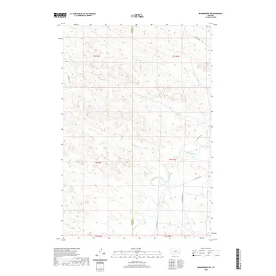
2020 Map of Brandenberg NW
USGS Topo · Published 2020About this map
The Tongue River meanders through the heart of this landscape along the border of Rosebud and Custer counties, anchoring a network of seasonal drainages and rural access routes. The river’s path defines the valley floor, flanked by Tongue River Rd and punctuated by the inflows of Cottonwood Cr and Liscom Cr. This terrain is characterized by a high density of named watercourses, including Coal Cr, Ranch Cr, and Garden Cr, which have carved the surrounding highlands into a complex system of ridges and draws. Remote access is provided by localized corridors such as Cherry Cr Rd and Fjord Ln, reflecting a ranching and agricultural infrastructure typical of southeastern Montana. The convergence of these numerous creeks into the primary river valley illustrates the fundamental hydrologic patterns that have historically dictated settlement and land use in this part of the state.
Find a feature on this map
20 named features on this map. Tap any name to fly to it.
Don’t see what you’re looking for? This feature index may not catch every label — zoom into the map to look around manually.
Map Details
Editions of this 2020 Brandenberg NW Map
This is the sole edition of this map. No revisions or reprints were ever made.
Other maps of this area

1954 · Hardin
USGS Topo · 1:250,000

1954 · Forsyth
USGS Topo · 1:250,000

1957 · Hardin
USGS Topo · 1:250,000

1957 · Forsyth
USGS Topo · 1:250,000

1958 · Forsyth
USGS Topo · 1:250,000

1958 · Hardin
USGS Topo · 1:250,000
1969 · Miller Creek
USGS Topo · 1:24,000
1969 · Miller Creek SW
USGS Topo · 1:24,000
1971 · Brandenberg NW
USGS Topo · 1:24,000

1971 · Hammond Draw
USGS Topo · 1:24,000