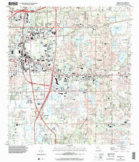
1999 Map of Brandon
USGS Topo · Published 2002About this map
The Alafia River and its nearby Buckhorn Spring define the southern landscape of this Hillsborough County survey, where suburban expansion meets the region's agricultural roots. The transition of the late 1990s is visible in the dense grid of residential neighborhoods expanding around historic cores like Brandon and Valrico. Large-scale infrastructure, including several major highway interchanges like Interchange 49 and Interchange 52, highlights the area's role as a commuter hub for Tampa.
Find a feature on this map
72 named features on this map. Tap any name to fly to it.
Don’t see what you’re looking for? This feature index may not catch every label — zoom into the map to look around manually.
Map Details
Editions of this 1999 Brandon Map
This is the sole edition of this map. No revisions or reprints were ever made.
Other maps of this area

1921 · Tampa
USGS Topo · 1:62,500

1943 · Thonotosassa
USGS Topo · 1:24,000

1944 · Sulphur Springs
USGS Topo · 1:31,680

1944 · Mango
USGS Topo · 1:31,680

1944 · Tampa
USGS Topo · 1:31,680

1944 · Thonotosassa
USGS Topo · 1:31,680

1944 · Antioch
USGS Topo · 1:31,680

1944 · Balm
USGS Topo · 1:31,680

1945 · Gadsden Point
USGS Topo · 1:31,680

1945 · Sulphur Springs
USGS Topo · 1:31,680