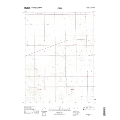
2017 Map of Brandon SE
USGS Topo · Published 2017About this map
Spring Cr flows through the southwestern corner of this Perkins County landscape, marking one of the few named natural water features in an area defined by its systematic agricultural grid. The terrain is characterized by the rolling sandhills of western Nebraska, where the land is divided into the large townships of t10n r40w and t10n r39w. Unlike more densely settled regions, this area remains dominated by open range and dryland farming, with the human imprint most visible in the network of section-line roads like RD 761 and Co RD 324 that provide access to remote farmsteads and grazing lands. The map illustrates the specialized rural infrastructure of the High Plains, where elevation contours and seasonal wetlands dictate the placement of local routes such as Co RD 757 and RD 758.
Find a feature on this map
22 named features on this map. Tap any name to fly to it.
Don’t see what you’re looking for? This feature index may not catch every label — zoom into the map to look around manually.
Map Details
Editions of this 2017 Brandon SE Map
This is the sole edition of this map. No revisions or reprints were ever made.
Other maps of this area

1954 · McCook
USGS Topo · 1:250,000

1957 · McCook
USGS Topo · 1:250,000

1958 · McCook
USGS Topo · 1:250,000

1961 · Brandon NE
USGS Topo · 1:24,000

1961 · Lamar NE
USGS Topo · 1:24,000

1961 · Brandon NW
USGS Topo · 1:24,000

1961 · Brandon SE
USGS Topo · 1:24,000

1961 · Lamar NW
USGS Topo · 1:24,000

1961 · Brandon
USGS Topo · 1:24,000
1973 · Grant
USGS Topo · 1:24,000