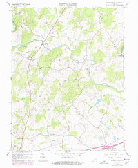
1966 Map of Brandy Station
USGS Topo · Published 1978About this map
Brandy Station sits at the southern edge of this landscape, positioned along the Southern railroad line where the terrain transitions from the lowlands of Flat Run toward the prominent rise of Fleetwood Hill. The map documents a predominantly rural Virginia countryside in the mid-1960s, punctuated by small crossroads settlements like Rixeyville and Alanthus. The winding courses of the Hazel River and Thornton River define the local geography, with the Kerrick Bridge Gaging Sta monitoring the Hazel's flow. Local community life is anchored by numerous country churches and small schools, including Oak Shade Ch, Shiloh Ch, and the Rixeyville Sch. To the northwest, the elevation increases toward Sheads Mtn, while the border between Culpeper Co and Fauquier Co follows the river's path through the northeastern corner near Lakota.
Find a feature on this map
35 named features on this map. Tap any name to fly to it.
Don’t see what you’re looking for? This feature index may not catch every label — zoom into the map to look around manually.
Map Details
Editions of this 1966 Brandy Station Map
3 editions found
Other maps of this area

1887 · Spottsylvania
USGS Topo · 1:125,000

1892 · Spottsylvania
USGS Topo · 1:125,000

1892 · Gordonsville
USGS Topo · 1:125,000

1893 · Luray
USGS Topo · 1:125,000

1894 · Warrenton
USGS Topo · 1:125,000

1894 · Warrenton
USGS Topo · 1:62,500

1905 · Luray
USGS Topo · 1:125,000

1927 · Remington
USGS Topo · 1:48,000

1930 · Warrenton
USGS Topo · 1:62,500

1943 · Germanna Bridge
USGS Topo · 1:24,000