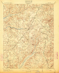
1913 Map of Brandywine
USGS Topo · Published 1913About this map
Brandywine serves as a central junction for early 20th-century Maryland life, positioned at the intersection of several growing districts and rail lines. The landscape is defined by the winding course of Zekiah Swamp and Mattawoman Creek, which delineate the boundaries between Prince George's and Charles counties. Large unincorporated areas are punctuated by small rural centers like Waldorf, Bryantown, and Beantown, each reflecting the agricultural and social hubs of the era. The presence of the Reform School near Cheltenham and various educational and religious landmarks, such as the Winkler Shop School and St Peters Church, provides a clear view of the region's social infrastructure.
Find a feature on this map
58 named features on this map. Tap any name to fly to it.
Don’t see what you’re looking for? This feature index may not catch every label — zoom into the map to look around manually.
Map Details
Editions of this 1913 Brandywine Map
3 editions found
Other maps of this area

1889 · Fredericksburg
USGS Topo · 1:125,000

1890 · Mt. Vernon
USGS Topo · 1:125,000

1891 · Mt. Vernon
USGS Topo · 1:125,000

1892 · Leonardtown
USGS Topo · 1:62,500

1892 · Fredericksburg
USGS Topo · 1:125,000

1892 · Prince Frederick
USGS Topo · 1:62,500

1892 · Brandywine
USGS Topo · 1:62,500

1892 · Owensville
USGS Topo · 1:62,500

1894 · Wicomico
USGS Topo · 1:62,500

1894 · Fredericksburg
USGS Topo · 1:125,000