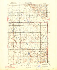
1946 Map of Brantford
USGS Topo · Published 1946About this map
Brantford and Grace City serve as the primary rail-oriented hubs in this mid-century portrait of the North Dakota prairie. The landscape is defined by the winding course of the James River and a scattering of glacial water bodies like Lake Washington and Cherry Lake. The Great Northern railroad provides the backbone for the local economy, cutting diagonally across the townships of Pleasant Prairie and Larrabee.
Find a feature on this map
27 named features on this map. Tap any name to fly to it.
Don’t see what you’re looking for? This feature index may not catch every label — zoom into the map to look around manually.
Map Details
Editions of this 1946 Brantford Map
2 editions found
Other maps of this area

1900 · Pingree
USGS Topo · 1:125,000

1928 · Tokio
USGS Topo · 1:62,500

1930 · Hamar
USGS Topo · 1:62,500

1931 · Oberon
USGS Topo · 1:62,500

1931 · Tokio
USGS Topo · 1:62,500

1944 · Brantford
USGS Topo · 1:62,500

1946 · Brantford
USGS Topo · 1:62,500

1948 · New Rockford
USGS Topo · 1:62,500

1948 · Carrington
USGS Topo · 1:62,500

1949 · Grace City
USGS Topo · 1:24,000