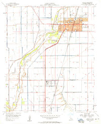
1957 Map of Brawley
USGS Topo · Published 1958About this map
The New River carves a winding path through this highly engineered agricultural landscape of the Imperial Valley during the late 1950s. The city of Brawley serves as a dense municipal hub, defined by a grid of schools including Union HS, Reid Sch, and Hidalgo Sch. The map reveals a sophisticated irrigation and drainage network essential to the region's desert farming, featuring the Westside Main Canal and numerous laterals like Newside Lateral 4.
Find a feature on this map
60 named features on this map. Tap any name to fly to it.
Don’t see what you’re looking for? This feature index may not catch every label — zoom into the map to look around manually.
Map Details
Editions of this 1957 Brawley Map
4 editions found
Other maps of this area

1907 · Holtville
USGS Topo · 1:125,000

1915 · El Centro
USGS Topo · 1:125,000

1940 · Brawley
USGS Topo · 1:62,500

1940 · Iris
USGS Topo · 1:62,500

1940 · Alamorio
USGS Topo · 1:62,500

1942 · El Centro
USGS Topo · 1:250,000

1943 · Brawley
USGS Topo · 1:62,500

1944 · Calipatria
USGS Topo · 1:62,500

1945 · Alamorio
USGS Topo · 1:62,500

1945 · Iris
USGS Topo · 1:62,500