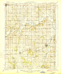
1924 Map of Braymer
USGS Topo · Published 1924About this map
Braymer and Cowgill anchor this Missouri landscape in the mid-1920s, a region defined by a remarkably dense network of rural schoolhouses and country churches. The Chicago Milwaukee and St. Paul railroad bisects the terrain, providing a vital transport artery through Lincoln and Davis townships. The topography is characterized by the winding path of Shoal Creek, which is crossed by the Gould Farm Bridge and fed by numerous tributaries like Dead Oak Branch and Turkey Creek.
Find a feature on this map
72 named features on this map. Tap any name to fly to it.
Don’t see what you’re looking for? This feature index may not catch every label — zoom into the map to look around manually.
Map Details
Editions of this 1924 Braymer Map
3 editions found
Other maps of this area

1889 · Lexington
USGS Topo · 1:125,000

1894 · Independence
USGS Topo · 1:125,000

1921 · Chillicothe
USGS Topo · 1:62,500

1922 · Gallatin
USGS Topo · 1:62,500

1923 · Chillicothe
USGS Topo · 1:62,500

1924 · Polo
USGS Topo · 1:62,500

1924 · Dawn
USGS Topo · 1:62,500

1924 · Braymer
USGS Topo · 1:62,500

1924 · Winston
USGS Topo · 1:62,500

1950 · Kansas City
USGS Topo · 1:250,000