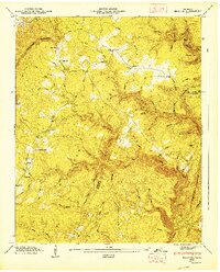
1947 Map of Brayton
USGS Topo · Published 1947About this map
Walden Ridge dominates this 1947 topographical landscape, where the plateau surface meets the dramatic drop of the Cumberland Escarpment. Small upland settlements and rural gathering places like Brayton, Smithtown, and Hickory Grove are connected by winding mountain roads and gaps in the ridge. Evidence of local life is found at Brayton Ch and the Hendon Cem near the community of Hendon. The terrain is deeply dissected by a dense network of watercourses, including Rock Creek and Roaring Creek, which have carved out notable landforms such as Turkey Hollow and Coalbank Hollow. A prominent Lookout Tower stands as a sentinel over the plateau, while names like Ferry Creek and Shingle Mill Hollow suggest the historical importance of waterway crossings and early timber industries in this corner of the Cumberland Plateau.
Find a feature on this map
61 named features on this map. Tap any name to fly to it.
Don’t see what you’re looking for? This feature index may not catch every label — zoom into the map to look around manually.
Map Details
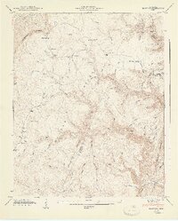
Editions of this 1947 Brayton Map
2 editions found
Other maps of this area

1888 · Chattanooga
USGS Topo · 1:125,000

1892 · Pikeville
USGS Topo · 1:125,000

1893 · Chattanooga
USGS Topo · 1:125,000

1895 · Pikeville
USGS Topo · 1:125,000

1909 · Sequatchie Valley
USGS Topo · 1:62,500

1910 · Pikeville
USGS Topo · 1:62,500

1935 · Morgan Springs
USGS Topo · 1:24,000

1935 · Soddy
USGS Topo · 1:24,000

1935 · Brockdell
USGS Topo · 1:24,000

1935 · Brayton
USGS Topo · 1:24,000