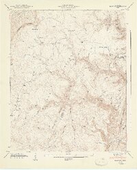
1947 Map of Brayton
USGS Topo · Published 1947About this map
Walden Ridge dominates this 1946 field-checked landscape, where the sharp descent of the Cumberland Escarpment meets the deep carved drainage of the Mc G I L L G U L F. This survey, produced by the Tennessee Valley Authority and the USGS, documents a rural highlands community defined by family-named hollows and isolated mountain settlements. The village of Brayton sits as a central hub, supported by the nearby Brayton Ch, while smaller clusters like Smithtown and Hickory Grove line the winding upland routes.
Find a feature on this map
71 named features on this map. Tap any name to fly to it.
Don’t see what you’re looking for? This feature index may not catch every label — zoom into the map to look around manually.
Map Details
Editions of this 1947 Brayton Map
2 editions found
Other maps of this area

1888 · Chattanooga
USGS Topo · 1:125,000

1892 · Pikeville
USGS Topo · 1:125,000

1893 · Chattanooga
USGS Topo · 1:125,000

1895 · Pikeville
USGS Topo · 1:125,000

1909 · Sequatchie Valley
USGS Topo · 1:62,500

1910 · Pikeville
USGS Topo · 1:62,500

1935 · Morgan Springs
USGS Topo · 1:24,000

1935 · Soddy
USGS Topo · 1:24,000

1935 · Brockdell
USGS Topo · 1:24,000

1935 · Brayton
USGS Topo · 1:24,000