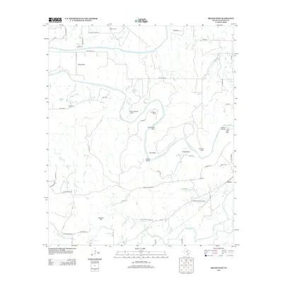
2012 Map of Brazos West
USGS Topo · Published 2012About this map
The Brazos River creates a series of dramatic loops and bends through this stretch of Palo Pinto County, shaping a landscape of deep hollows and high points. Settlements such as Sand Valley and New Hope occupy the relatively level ground between the river and the surrounding elevations. Near the settlement of New Hope, the New Hope Cem serves as a key point of reference for local family history. To the south, the terrain rises toward Robinson Mtn, while the river continues its winding path past uniquely named features like Brewton Canyon Polk Stalk Bend and Hogpen Hollow. The presence of the Matthews Ranch Airport near the eastern border illustrates the modern intersection of private aviation and large Texas ranching properties. Transport is facilitated by rural routes like Farm-to-Market Road 129, connecting the small community of Brazos to the surrounding cattle country.
Find a feature on this map
54 named features on this map. Tap any name to fly to it.
Don’t see what you’re looking for? This feature index may not catch every label — zoom into the map to look around manually.
Map Details
Editions of this 2012 Brazos West Map
This is the sole edition of this map. No revisions or reprints were ever made.
Other maps of this area

1891 · Palo Pinto
USGS Topo · 1:125,000

1918 · Palo Pinto
USGS Topo · 1:125,000

1925 · Palo Pinto 4-b
USGS Topo · 1:48,000

1927 · Pickwick
USGS Topo · 1:62,500

1927 · Mineral Wells
USGS Topo · 1:62,500

1931 · Santo
USGS Topo · 1:62,500

1954 · Abilene
USGS Topo · 1:250,000

1958 · Abilene
USGS Topo · 1:250,000

1958 · Palo Pinto
USGS Topo · 1:62,500
1959 · Mineral Wells
USGS Topo · 1:62,500