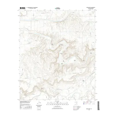
2016 Map of Brazos West
USGS Topo · Published 2016About this map
The Brazos River snakes through the heart of Palo Pinto County, carving a series of dramatic loops including John Hittson Bend, Whitley Bend, and Polk Stalk Bend. This 2016 survey captures a landscape of intense relief, where the river's winding course is hemmed in by high ground like Chesnut Mountain and Robinson Mtn. Local industry and rural infrastructure are marked by the Kirpatrick Oil & Gas Co Rd and the Matthews Ranch Airport, which sit near the lower drainage of Palo Pinto Creek. Smaller rural hubs like New Hope, with its accompanying New Hope Cem, and Sand Valley provide a grounded look at the enduring community layout of the region. The map also records numerous drainages such as Baker Cr and Rock Cr that feed into the main river system through terrain features like Hogpen Hollow and Brewton Canyon.
Find a feature on this map
51 named features on this map. Tap any name to fly to it.
Don’t see what you’re looking for? This feature index may not catch every label — zoom into the map to look around manually.
Map Details
Editions of this 2016 Brazos West Map
This is the sole edition of this map. No revisions or reprints were ever made.
Other maps of this area

1891 · Palo Pinto
USGS Topo · 1:125,000

1918 · Palo Pinto
USGS Topo · 1:125,000

1925 · Palo Pinto 4-b
USGS Topo · 1:48,000

1927 · Pickwick
USGS Topo · 1:62,500

1927 · Mineral Wells
USGS Topo · 1:62,500

1931 · Santo
USGS Topo · 1:62,500

1954 · Abilene
USGS Topo · 1:250,000

1958 · Abilene
USGS Topo · 1:250,000

1958 · Palo Pinto
USGS Topo · 1:62,500
1959 · Mineral Wells
USGS Topo · 1:62,500