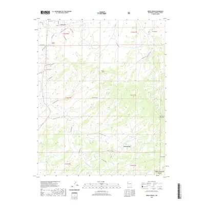
2020 Map of Bread Springs
USGS Topo · Published 2020About this map
The high desert landscape south of Gallup is defined by a network of complex canyons and ephemeral washes. This 2020 survey details the transition from the city's outskirts into the Cibola National Forest, showing how modern residential development like Catalpa Canyon meets traditional land uses. The settlement of Bread Springs sits centrally along its namesake Bread Springs Wash, serving as a focal point for a region crisscrossed by tribal service routes and local roads. Significant topographic landmarks such as The Hogback and Umbrella Rock provide vertical orientation across the varied terrain. Evidence of the area's resource-driven history is preserved in names like Sundance Coal Mine Rd, while unique local toponyms like Fenced-Up Horse Valley and Blue Medicine Well Rd offer clues to the cultural and agricultural heritage of the McKinley County backcountry.
Find a feature on this map
41 named features on this map. Tap any name to fly to it.
Don’t see what you’re looking for? This feature index may not catch every label — zoom into the map to look around manually.
Map Details
Editions of this 2020 Bread Springs Map
This is the sole edition of this map. No revisions or reprints were ever made.
Other maps of this area

1886 · Wingate
USGS Topo · 1:250,000

1892 · Wingate
USGS Topo · 1:250,000

1954 · Gallup
USGS Topo · 1:250,000

1958 · Gallup
USGS Topo · 1:250,000

1959 · Gallup
USGS Topo · 1:250,000

1962 · Gallup
USGS Topo · 1:250,000

1963 · Twin Buttes
USGS Topo · 1:24,000

1963 · Gallup West
USGS Topo · 1:24,000
1963 · Church Rock
USGS Topo · 1:24,000

1963 · Pinehaven
USGS Topo · 1:24,000
Featured Places
- Gallup, NM
- Eastern Navajo Agency, NM
- Sundance, Eastern Navajo Agency
- Bread Springs, Eastern Navajo Agency
- McKinley County, NM