
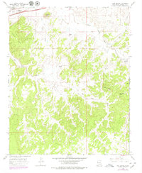
1963 Map of Twin Buttes
USGS Topo · Published 1967About this map
Torrivio Mesa and the surrounding high desert terrain dominate this mid-century survey of McKinley County. The landscape is defined by its drainage patterns, with Twin Buttes Wash and Bread Springs Wash carving through the mesas toward the Puerco River in the northwest. Human activity is concentrated along the northern corridor, where the At&Sf railroad and Highways 66 666 skirt the edges of the highland, providing a lifeline for small settlements like Williams Acres.
Find a feature on this map
18 named features on this map. Tap any name to fly to it.
Don’t see what you’re looking for? This feature index may not catch every label — zoom into the map to look around manually.
Map Details
Editions of this 1963 Twin Buttes Map
2 editions found
Other maps of this area

1886 · Wingate
USGS Topo · 1:250,000

1892 · Wingate
USGS Topo · 1:250,000

1954 · Gallup
USGS Topo · 1:250,000

1958 · Gallup
USGS Topo · 1:250,000

1959 · Gallup
USGS Topo · 1:250,000

1962 · Gallup
USGS Topo · 1:250,000

1963 · Gallup West
USGS Topo · 1:24,000

1963 · Manuelito
USGS Topo · 1:24,000

1963 · Jones Ranch School
USGS Topo · 1:24,000

1963 · Pinehaven
USGS Topo · 1:24,000
Featured Places
- Gallup, NM
- Eastern Navajo Agency, NM
- Red Rock, Eastern Navajo Agency
- Williams Acres, NM
- McKinley County, NM