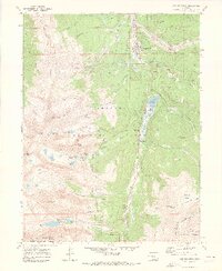
1970 Map of Breckenridge
USGS Topo · Published 1973About this map
Breckenridge sits at the heart of this high-altitude landscape, captured in 1970 as the area transitioned from its deep mining roots into a premier alpine destination. The map details the nascent Sawmill Ski Area on the slopes below the Tenmile Range, marking a pivotal shift in land use. Meanwhile, the legacy of the late 19th-century boom is still plainly visible through an extensive network of gulches and lodes, including the Wellington Mine in French Gulch and the Briar Rose Mine on the shoulder of Peak 10. Hydrological engineering for the growing Front Range is evidenced by the Blue River Diversion Project, which includes a tunnel system beneath the Continental Divide. From the peaks of Quandary Peak and Pacific Peak to the waters of Goose Pasture Tarn, the map documents a terrain defined by rugged relief and resource management.
Find a feature on this map
67 named features on this map. Tap any name to fly to it.
Don’t see what you’re looking for? This feature index may not catch every label — zoom into the map to look around manually.
Map Details
Editions of this 1970 Breckenridge Map
3 editions found
Other maps of this area

1889 · Leadville
USGS Topo · 1:125,000

1891 · Leadville
USGS Topo · 1:125,000

1924 · Montezuma
USGS Topo · 1:62,500

1926 · Montezuma
USGS Topo · 1:62,500

1929 · Dillon
USGS Topo · 1:62,500

1933 · Montezuma
USGS Topo · 1:62,500

1934 · Climax
USGS Topo · 1:48,000

1934 · Dillon
USGS Topo · 1:62,500

1937 · Como
USGS Topo · 1:62,500

1938 · Mt. Lincoln
USGS Topo · 1:48,000