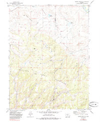
1971 Map of Breeze Mountain
USGS Topo · Published 1985About this map
Williams Fork Mountains dominate the southern portion of this 1971 survey, where the rugged topography is defined by a dense network of gulches and ridges. The landscape is characterized by its resource extraction and aviation history, notably featuring the Jim Dunn Mine and an Airway Beacon situated on the slopes of Breeze Mountain. The transition from the high peaks like Buck Peak down to the Yampa River in the northeast corner reveals a reliance on water management in this arid region, evidenced by the presence of Dresher Reservoir, Biskup Res, and Basin Reservoir.
Find a feature on this map
31 named features on this map. Tap any name to fly to it.
Don’t see what you’re looking for? This feature index may not catch every label — zoom into the map to look around manually.
Map Details
Editions of this 1971 Breeze Mountain Map
4 editions found
Other maps of this area

1910 · Danforth Hills
USGS Topo · 1:125,000

1915 · Monument Butte
USGS Topo · 1:62,500

1916 · Craig
USGS Topo · 1:125,000

1916 · Daton Peak
USGS Topo · 1:62,500

1920 · Daton Peak
USGS Topo · 1:62,500

1923 · Elkhead Creek
USGS Topo · 1:62,500

1924 · Elkhead Creek
USGS Topo · 1:62,500

1954 · Craig
USGS Topo · 1:250,000

1957 · Craig
USGS Topo · 1:250,000

1958 · Craig
USGS Topo · 1:250,000