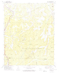
1973 Map of Brentwood
USGS Topo · Published 1976About this map
Brentwood sits at the junction of mountain valley topography and industrial transit in the early 1970s, where the St Louis San Francisco RR tracks parallel the West Fork White River. This portion of the Ozark National Forest is marked by a deep network of hollows, such as Paschal Hollow and Sugar Tree Hollow, that have historically shaped local settlement patterns. Genealogists will find significant detail in the placement of rural cemeteries and spiritual sites, including Parks Cem, Koyle Cem, and the prominent Our Lady of the Ozarks Shrine near Mount Gaylor. The map also captures the path of the Henderson Mountain Pipeline as it traverses the ridge lines. To the east, the community of Sunset and the Middle Fork White River define a landscape of secluded drainage basins like Tom Ritter Hollow, illustrating the enduring isolation and specific geography of the Washington and Crawford County border.
Find a feature on this map
44 named features on this map. Tap any name to fly to it.
Don’t see what you’re looking for? This feature index may not catch every label — zoom into the map to look around manually.
Map Details
Editions of this 1973 Brentwood Map
3 editions found
Other maps of this area

1879 · Cravens
USGS Topo · 1:62,500

1887 · Watalula
USGS Topo · 1:62,500

1898 · Winslow #4
USGS Topo · 1:62,500

1898 · Winslow
USGS Topo · 1:125,000

1901 · Winslow
USGS Topo · 1:125,000

1939 · Watalula
USGS Topo · 1:62,500

1943 · St. Paul
USGS Topo · 1:62,500

1946 · St. Paul
USGS Topo · 1:62,500

1946 · Fort Smith
USGS Topo · 1:250,000

1956 · Russellville
USGS Topo · 1:250,000