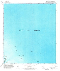
1971 Map of Breton Islands SE
USGS Topo · Published 1972About this map
The coastal waters of the Gulf of Mexico dominate this orthophotomap, revealing the intensive maritime and industrial activity off the Louisiana coast in the early 1970s. This survey, compiled from high-altitude aerial photography and hydrographic data, captures the industrial footprint of the Block 69 Oil Field and adjacent Oil Field areas. Scattered across the water are numerous offshore platforms and oil wells, demonstrating the scale of mineral extraction in the deltaic region. In the lower corner, the shifting coastal geography is visible through features like Japan Island and the marshy perimeter of Japan Outside Pond. This area is intersected by the notable coastal waterway Dead Women Pass, providing a precise look at the interface between the fragile marsh landscape and the heavy infrastructure required for deep-water energy production during this era.
Find a feature on this map
10 named features on this map. Tap any name to fly to it.
Don’t see what you’re looking for? This feature index may not catch every label — zoom into the map to look around manually.
Map Details
Editions of this 1971 Breton Islands SE Map
2 editions found
Other maps of this area

1893 · East Delta
USGS Topo · 1:62,500

1947 · Pass A Loutre West
USGS Topo · 1:31,680

1947 · Main Pass
USGS Topo · 1:31,680

1947 · Pass A Loutre East
USGS Topo · 1:31,680
1950 · Breton Islands
USGS Topo · 1:24,000

1953 · Breton Island
USGS Topo · 1:62,500
1954 · Pass A Loutre East
USGS Topo · 1:31,680
1954 · Pass A Loutre West
USGS Topo · 1:31,680
1954 · East Delta
USGS Topo · 1:62,500

1957 · Breton Sound
USGS Topo · 1:250,000