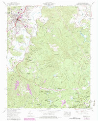
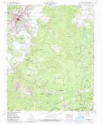
1965 Map of Brevard
USGS Topo · Published 1978About this map
Brevard serves as the regional hub for this portion of the Blue Ridge, situated along the Southern RR railway at the edge of the Pisgah National Forest. The landscape is defined by the winding course of the French Broad River and a dense network of mountain peaks, including Sugar Loaf Mountain and Dunns Rock. By the mid-1960s, the area supported a mix of residential growth in Broadview Estates and Forest Hills, alongside a significant concentration of summer camps and institutional sites like Greenville Elks Childrens Camp and Camp Burgess Glen (YWCA).
Find a feature on this map
84 named features on this map. Tap any name to fly to it.
Don’t see what you’re looking for? This feature index may not catch every label — zoom into the map to look around manually.
Map Details
Editions of this 1965 Brevard Map
5 editions found
Other maps of this area

1905 · Pisgah
USGS Topo · 1:125,000

1906 · Pisgah
USGS Topo · 1:125,000

1935 · Brevard
USGS Topo · 1:24,000

1935 · Eastatoe Gap
USGS Topo · 1:24,000

1935 · Standingstone Mtn.
USGS Topo · 1:24,000

1935 · Horse Shoe
USGS Topo · 1:24,000

1935 · Rosman
USGS Topo · 1:24,000

1935 · Table Rock
USGS Topo · 1:24,000

1935 · Shining Rock
USGS Topo · 1:24,000

1935 · Pisgah Forest
USGS Topo · 1:24,000