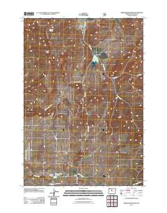
2011 Map of Brewer Reservoir
USGS Topo · Published 2011About this map
Hay Creek Ranch and Morrow Ranch anchor this landscape in Jefferson County, where ranching operations and water management systems dominate the geography. The map shows a series of vital water resources for the region, including Brewer Reservoir held by Brewer Dam, and Willow Creek Reservoir downstream of the Morrow Brothers Dam. These features illustrate the infrastructure required to manage seasonal water flow in the high country, where Hay Creek and Willow Creek provide the primary drainage.
Find a feature on this map
18 named features on this map. Tap any name to fly to it.
Don’t see what you’re looking for? This feature index may not catch every label — zoom into the map to look around manually.
Map Details
Editions of this 2011 Brewer Reservoir Map
This is the sole edition of this map. No revisions or reprints were ever made.
Other maps of this area

1926 · Bend
USGS Topo · 1:125,000

1928 · Madras
USGS Topo · 1:125,000

1929 · Bend
USGS Topo · 1:125,000

1931 · Madras
USGS Topo · 1:125,000

1955 · Bend
USGS Topo · 1:250,000

1957 · Bend
USGS Topo · 1:250,000

1958 · Bend
USGS Topo · 1:250,000
1962 · Gray Butte
USGS Topo · 1:24,000

1962 · Prineville
USGS Topo · 1:62,500
1963 · Madras East
USGS Topo · 1:24,000