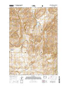
2014 Map of Brewer Reservoir
USGS Topo · Published 2014About this map
Crooked River National Grassland dominates the southwestern portion of this Central Oregon landscape, where the high desert terrain is carved by a complex network of canyons and seasonal drainages. The map reveals a land managed for water and grazing, anchored by the Brewer Reservoir and Willow Reservoir. These artificial water bodies, along with Anderson Springs, provide critical points of interest in an otherwise arid environment defined by the Baldwin Hills and the deep incisions of Wagonblast Canyon and Red Shed Canyon. Navigational routes like Haycreek Rd and Se Grizzly Rd trace the paths between the drainages of Hay Cr and Mud Springs Cr, illustrating how human infrastructure adapts to the natural contours of the Jefferson County plateau. This 2014 survey serves as a clear record of modern land use and topography within the grassland's boundaries.
Find a feature on this map
22 named features on this map. Tap any name to fly to it.
Don’t see what you’re looking for? This feature index may not catch every label — zoom into the map to look around manually.
Map Details
Editions of this 2014 Brewer Reservoir Map
This is the sole edition of this map. No revisions or reprints were ever made.
Other maps of this area

1926 · Bend
USGS Topo · 1:125,000

1928 · Madras
USGS Topo · 1:125,000

1929 · Bend
USGS Topo · 1:125,000

1931 · Madras
USGS Topo · 1:125,000

1955 · Bend
USGS Topo · 1:250,000

1957 · Bend
USGS Topo · 1:250,000

1958 · Bend
USGS Topo · 1:250,000
1962 · Gray Butte
USGS Topo · 1:24,000

1962 · Prineville
USGS Topo · 1:62,500
1963 · Madras East
USGS Topo · 1:24,000